
 * Liquefaction Formed Continent-wide Flat-Gap Strata: On the world's continents there are beautifully uniform and "flat-gap" boundaries, as though formed by a putty knife, between sediments over hundreds of thousands of square miles around the globe. To a significant degree, these flat boundaries between strata are the result of the sorting after burial of minerals (along with animal fossils and vegetation in coal seams, etc.). Thus liquefaction helps to explain both the geologic column and the formation of highly purified (limestone, diatomaceous, etc.) deposits, through its potential for even continent-wide sorting of minerals into finely differentiated layers.
* Kevin Lea on Today's RSR: In this special edition of Real Science Radio, Kevin Lea, with his great knowledge of earthquakes, talks with Bob Enyart about a significant effect of earthquakes and strong tectonic activity: liquefaction. Pastor Lea of Calvary Church, Port Orchard, Washington, and Bob use Dr. Walt Brown's book In the Beginning as a guide to understand the worldwide effects that resulted from when the fountains of the great deep broke forth in the global flood.
* The "Law of Superposition" Is Wrong: As a general description of the world's sedimentary layers, this alleged natural "law" wrongly claims that, "Sedimentary layers are deposited in a time sequence, with the oldest on the bottom and the youngest on the top." In reality, a tremendous amount of sorting of minerals and fossils occurred underground when the continents' mile-deep sediments were first deposited.
* Two Post-show Program Notes on Related Stratification Mechanisms
- RSR's Grand Canyon series: Consider the canyon's "missing erosion" problem (in part 2 of our series) and the liquefaction solution to that problem (beginning at 25 minutes into in part 4.)
- Guy Berthault and Strata Formation: Additionally, as has been demonstrated by Guy Berthault's research in an RSR interview, describing experiments including with the massive laboratory flume operated by the University of Northern Colorado, fast running water deposits multiple layers nearly simultaneously, as multiple layers are deposited at virtually the same time in the direction of the flow at the leading edge of the new deposit. See video of these experiments and hear our interview on this at rsr.org/guy-berthault. This phenomenon explains some deposits, but liquefaction explains the massive, continent-wide mineral sorting into flat-gap strata.
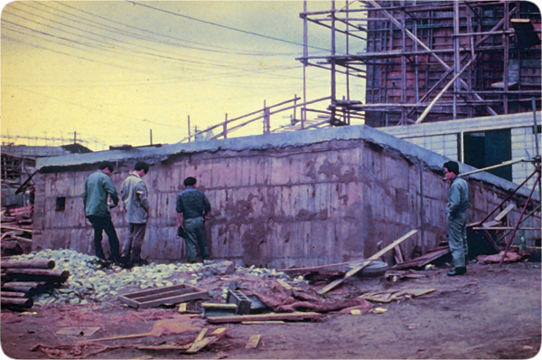 * What is Liquefaction: See the formerly buried concrete structure on the right, which floated up during a Japan earthquake. Walt Brown quotes geologist Arthur Strahler, from book, Physical Geology, "These water-saturated deposits often experience a change in property known as liquefaction when shaken by an earthquake. The material loses strength to the degree that it becomes a highly fluid mud..." Kevin reports that after a recent Washington earthquake, geologists asked residents to report any sightings of mud flowing out of the ground so that they can better understand the dynamics of liquefaction.
* How Did Millions of Fish Get Squished Flat? By liquefaction! Listen and enjoy!
 * Bob and KevinDiscusss Liquefaction Effects: Today's RSR program discusses the tectonic effects that occurred for months after the global flood, which sorted sediments worldwide, and also created plumes, mounds, the so-called geologic column, the extraordinary purity of enormous layers of strata, extremely well defined boundaries, cyclothems of repeating patterns of layers that include coal seams (going upward: coal, sandstone, shale, limestone, clay, finer clay; with the whole pattern repeating vertically sometimes dozens of times), and much of the characteristics of fossil-bearing strata. Noah's flood helps to explain the hundreds of thousands of square miles of sediments, with similar strata spanning, and even crossing over to other, continents.
* Other Great Kevin Lea Shows on Real Science Radio: Enjoy Kevin Lea, hydroplate expert, on the origin of comets, frozen mammoths (note, not "woolly"), and even the 365-day year.
Today's Resource: You can help us stay on the air by purchasing the Real Science Radio Collection, a handy set of MP3 CDs with all of our shows from 2006 to 2011. Also, you can enjoy Bob Enyart’s entertaining and insightful videos each month, mailed to you automatically, simply by subscribing to the BEL Monthly Topical Videos service! And please check out our other great BEL subscription services!
 Another Great Resource: The Hydroplate Theory & Walt Brown On the Air presents eleven 30-minute radio shows that aired on the most powerful Christian radio station in America, Denver's AM 670 KLTT! Hear Dr. Brown explain the Hydroplate Theory, and hear his great insights on the origin of the grand canyon, limestone, where the water went after the global flood, and on the theory of evolution. Hear also a Q&A session with Bob Enyart answering callers related questions. And enjoy Kevin Lea, hydroplate expert, on the origin of comets and about the frozen mammoths, earthquakes, and the origin of our 365-day year. Finally, Fred Williams and Bob present Walt's extensively researched hypothesis on the origin of Earth's radioactivity.
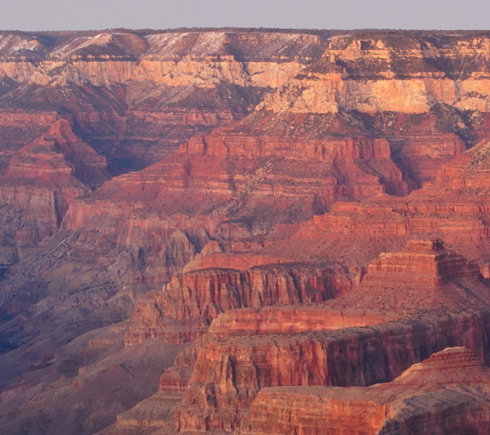
Post-show Question: Regarding the strata of the Grand Canyon, ask yourself if one or the other of these explanations is reasonable. (1) Between the layers that are marked below, many millions of years (as claimed by the passed without leaving a trace, with virtually no evidence of deposition nor erosion in these flat gaps? Or, that these layers, which extend for thousands of square miles and have analogs on continents around the world, were deposited rapidly, with liquefaction helping to explain the sorting of the sediments into such regular layers? (The information displayed on the following image is according to all old-earth geologists (and the dogma that they are not allowed to question) as it appears in this Geology of the Grand Canyon report available from the U.S. National Park Service.)

* Excerpt from Walt Brown's Liquefaction Chapter: Here's just one great excerpt from Dr. Brown's chapter on liquefaction:
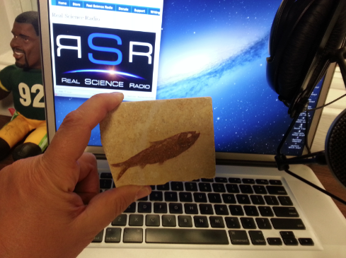
Varves are extremely thin layers (typically 0.004 inch or 0.1 mm), which evolutionists claim are laid down annually in lakes. By counting varves, evolutionists believe that time can be measured. The Green River Formation of Wyoming, Colorado, and Utah, a classic varve region, contains billions of flattened, paper-thin, fossilized fish; thousands were buried and fossilized in the act of swallowing other fish. [See Figure 7 on page 12.] Obviously, burial was sudden. Fish, lying on the bottom of a lake for years, would decay or disintegrate long before enough varves could bury them. (Besides, dead fish typically float, deteriorate, and then sink.) Most fish fossilized in varves show exquisite detail and are pressed to the thinness of a piece of paper, as if they had been compressed in a collapsing liquefaction lens. Also, varves are too uniform, show almost no erosion, and are deposited over wider areas than where streams enter lakes—where most lake deposits occur. Liquefaction best explains these varves.
To find out more, make sure to read Walt Brown's great liquefaction chapter online, or better yet, purchase his whole book, In the Beginning, from us right here at Real Science Radio!
* What is the volume of sedimentary rock on Earth? 200 million cubic miles! Or maybe not. It seems that the scientific literature does not present an easily discoverable estimate in answer to this question. So at quora.com Bob offers this:
200 million cubic miles of sediments might be in the ballpark. To arrive at that volume, consider the sources in these links:
- 41.8 million square miles (area) of sedimentary rock (73% of the 75.3 million sq miles of continents).
- (Sedimentary rock covers 21% (area) of Earth's total of 197 million square miles.)
- 8% of crust (volume) is sedimentary rock. (Crust is 2.6 billion cubic miles or 1% of Earth volume.)
- Thus continental sedimentary rock may be about 208 million cubic miles.
- (20 million cubic miles of limestone exist if the often repeated estimate is correct that limestone makes up 10% of sedimentary rock.)
- (Other estimates: sediments comprise 5% of the outer 10 miles of the Earth and 12% of the mass of the crust is quartz.)
I’d like input. I’m not an expert but am hoping those who are can improve on these numbers.